Fly Dane is a regional partnership that allows local agencies to pool their resources for periodic updates of orthophotography, elevation, and planimetric data.
Dane County participated in a federal GIS demonstration project (OrthoFinder) with the Wisconsin State Cartographer’s Office, University of Wisconsin-Madison, Wisconsin Dept. of Natural Resources, the City of Madison, and Ayres Associates. The project investigated issues related to the discovery, access, and use of digital orthophotography acquired by different agencies, at different times, over the same geography.
Dane County was selected because of its 15-year history of orthophotography projects. The Fly Dane 2000 project was reviewed as a case study for others who want to learn about digital ortho acquisition, project planning, institutional and policy issues, and partnership and collaboration opportunities. To learn more about the OrthoFinder tool or project, please visit the State Cartographers Office.
Modern technology makes it possible to produce a wide range of digital mapping products; orthoimagery is one such product that public agencies, private businesses, and others have increasingly utilized in the last decade. As digital mapping tools have developed, the landscapes being photographed and mapped have also been continually (and often rapidly) changing. This dynamic – of improving technology and changing land resources – makes it important, for users in both government and business, to routinely update digital imagery and the products created from such imagery.
It is not an easy task to create and maintain up-to-date digital orthoimagery. It is expensive, time consuming, and technically challenging to plan, acquire, and process aerial photos, create the mapping products, and manage their distribution. Public agencies or local units of government seldom have the resources to commit to such a project on their own – nor can individual private businesses afford the large investment. The dilemma is that it’s costly in terms of time and money, but it increasingly benefits many parties (in both the public and private sector). The challenge is to develop strategies to share in the investment to make the work possible.
There is no single right answer to how to pool resources to do orthophotography projects. They vary in their broad scope and their myriad details – and the technology is so new that a common project “framework” has not yet emerged. Valuable experience has been acquired in recent years, however, as Wisconsin counties and other local units of government have created an umber of consortiums to acquire and process aerial imagery. One recent project – called “Fly Dane 2000” – is an example of a successful partnership model that holds great promise for future work.
Fly Dane offers a good case study of a cooperative, locally-funded orthophotography project for several reasons:
Fly Dane 2000 was a collaborative effort among Dane County government, numerous county municipalities, and private partners to:
An equally important goal and by-product of the project was to upgrade the County’s survey control network. The network was inventoried, and additional horizontal and vertical control was established to enhance the network and provide an improved framework for a new terrain model and aerial photography. The data was later “bluebooked” (catalogued with the National Geodetic Survey) and used to develop a new survey data management system for the County Surveyor.
A total of forty-three project partners collaborated in Fly Dane 2000, including Dane County, the Regional Planning Commission and Metropolitan Planning Organization, 24 cities and villages, 15 towns, state and federal agencies, utilities, and a private business. The Dane County Land Information Office acted as the project coordinator; Fairview Industries assisted with project definition and alternatives, RFP development, and survey services; and Ayres Associates (a Madison-based photogrammetric mapping and engineering firm) was contracted to assist with partnership development and project deliverables.
It is important to emphasize the collaborative nature of Fly Dane. It was not designed as a County project, but rather as a partnership meant to benefit many contributors. The large number of participants and the evolution of contracted services to cover additional local services indicates that area-wide data needs were being addressed. The Fly Dane partnership is open and ongoing with new partners continuing to join.
This kind of collaboration obviously doesn’t just “happen” without a great deal of effort. It requires support from local political leaders, careful project planning, organizational and managerial skills on the part of project coordinators, and an active commitment from the project partners. These organizational factors are all important because of the multi-year nature of the project, its technical complexity, and the number of parties involved.
Initially Dane County considered a single agency project that would have used the older terrain model to produce updated ½ meter resolution imagery. The County could afford to fund this type of project on its own, but it would not have met county needs for an improved terrain model to support FEMA floodplain mapping, a new soils survey, stormwater management, and other projects. Municipalities also needed a more accurate terrain model and imagery for utility mapping and the development of 2’ contours for engineering work. The 1997 City of Madison orthophoto project had already demonstrated the value of this additional detail and accuracy at the municipal level. Neighboring municipalities were interested in improved terrain and image products but could not afford to acquire this data on their own. The partnership enabled them to get beyond budget limitations and the high cost of individual projects.
The Dane County Land Information Office and Ayres Associates began contacting potential partners early in the process. This was essential both to ensure their full commitment and participation and to enable partners to plan and budget for the project during their normal budget cycle.
Dane County and Ayres spent over a year meeting with local municipal staff and elected officials to explain the project. For each meeting, a CD was prepared with sample high resolution data, viewing software, and documents describing the project, partner options, and funding arrangements. This CD was left with the municipality to share with other staff and elected officials. Sample hard copy plots showed the difference between the 1995 1-meter imagery and the proposed 2000 1-foot and 6-inch image products. Information describing pre-flight targeting methods and materials were developed for discussions about utility mapping.
With many partners, Dane County and Ayres were able to demonstrate the value of the proposed products for projects and issues before them. One community had acquired planimetric data in the past but had no digital copies in-house. They needed to contact the previous vendor every time they needed additional hard copy prints. This municipality was interested in acquiring 6" imagery, so they could update planimetrics in the future and have it available in-house. A few months later, contract arrangements made it possible for them to develop the planimetric data as part of the Fly Dane project. Another community faced repeated flooding issues in an area and was interested in detailed terrain data to help with FEMA floodplain studies. Another local engineering firm that provided engineering services to several of the communities saw the value of this project for its clients. It would be faster and cheaper for the communities to acquire some of the needed data throughout the Fly Dane project, leaving the engineering firm to concentrate on enhancing the partnership products and providing other engineering services.
Many communities commented that this project represented just what the County should do to help them. Individually, communities were struggling with data acquisition costs. Many were just on the verge of implementing GIS and knew they would need this data, but it is often difficult to convince elected officials to commit to an emerging need. The County's ability to step forward in a coordinating role allowed communities to overcome budget limitations and justify the investment and timing to local officials.
Municipalities were particularly interested in better data to support floodplain determinations and appeals, engineering projects, and land use planning. (New Smart Growth legislation had just been passed in Wisconsin requiring all municipalities to develop comprehensive land use plans.) As the County became more familiar with the municipal needs, arrangements were made with Ayres to expand contracted services to allow individual municipalities to develop a denser terrain model to support higher resolution imagery and the development of planimetric and 2' contour data. Partners were kept updated on the project and partnership's development through status reports, partner meetings, and a project web site.
"Selling" the project was made easier by the fact that it was structured as a true partnership — it was voluntary, flexible in terms of meeting the partners' diverse needs and interests, and cost-effective. The "economies of scale" created by the partnership approach made it possible to greatly reduce the costs (in comparison to "go-it-alone" projects) and take advantage of those savings to create higher-quality products. Partners were also attracted to the long-term arrangements that would help assure the products would be updated and funded in future years. Partners helped establish product prices that balance data access and availability with the upfront investment needed to make the project happen.
Fly Dane was not Dane County’s first orthophotography project. In 1995, Dane County participated in a seven-county consortium that worked with Ayres Associates to create 1-meter resolution ortho imagery and data collections of 10-foot contours, road centerlines, and hydrologic features.
Planning for Fly Dane 2000 began in the fall of 1998. There was a consensus that the 1995 products needed to be improved upon, so the County asked Fairview Industries to help develop a Request for Proposal (RFP) that would assure creative options and alternatives (including partnerships) in the proposal responses. It was evident from the start that Ayres understood project needs and the special arrangements and commitment a partner project would require. The firm saw the benefits of a broader partnership and believed the extra efforts would be worth their investment as well as that of the partners. As a result, Ayres outlined the following as project guidelines.
Ayres then identified some specific ways to improve upon the 1995 products:
In addition, the project would include these products:
As noted, planning for Fly Dane began in the fall of 1998. In the spring of 1999, the County selected Ayres Associates as the primary vendor. Project staff from Dane County and Ayres Associates continued project preparations through 1999 and the first few months of 2000. By January 2000, the partnerships had been established and the first partnership meetings were initiated. Geodetic and survey photo control were established in February and March and aerial photos taken in March and April 2000. Data processing, quality control, and product development followed the photo acquisition and continued through the first half of 2001. Imagery products were delivered from January through July 2001.
An important aspect of the Fly Dane project was the close working relationship between the contractor and the County on quality control for the products. Because of the huge dollar investment, the project represented and because the work was accountable to so many partners, the County decided to conduct a second level of review on the deliverables. As imagery came in from Ayres, Dane County staff used an ArcView application to review the imagery for large dust spots or scratches, ghosting, and warping. An ArcView shapefile was generated noting the location and type of problem found. Ayres staff was able to quickly review the ArcView file and correct any problems with the imagery. Generally, imagery was reviewed, returned, corrected, and sent back to the County within five business days and caused no delay to the project schedule. The terrain data was also reviewed as part of the County’s in-house development of the countywide 4’ contours. Data was checked and compared to the other field engineering records. Where problems were found, Ayres quickly corrected the underlying terrain data and contour development continued.
The review process was beneficial to all parties, provided additional quality assurance, and automated processes in a manner that was fast, efficient, and allowed consistency between staff conducting the review.
Fly Dane 2000 produced the following products for its partnership. Partners have countywide access to all project deliverables; non-partners may purchase the products through the Dane County Land Information Office’s normal data distribution services.
Municipal partners may also elect to produce additional products from the data, such as 2 ft. contours or planimetrics. In addition to these products, other benefits include densification and adjustments to the survey control network, the development of a survey control inventory and database, and new digital hydrography and road centerline data sets.
Fly Dane imagery has been re-sampled to meet federal (NDOP) specifications (1-meter resolution) and made available in the public domain through the U.S. Geological Survey Innovative Partnership program. The same 1-meter resolution imagery has been made available in the OrbView Cities imagery distribution program. Dane County will receive a portion of the revenue from each imagery sale via Orbimage’s online catalog.
All proceeds from data sales are deposited into the Fly Dane Reserve Fund and will be used for future data updates.
Producing high-resolution aerial imagery is expensive. It was important for the success of Fly Dane 2000 that project costs be shared as widely and equitably as possible. A long list of project partners helped to fund the acquisition and processing of the aerial imagery.
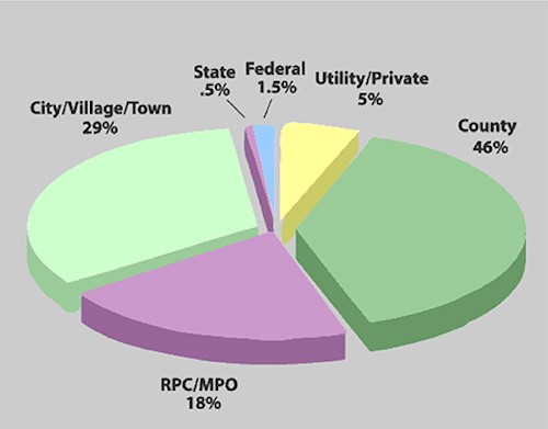
Expenditures for Fly Dane 2000 totaled about $1.1 million. Partners contributed to the project as shown in the graphic.
In addition, because Fly Dane was formed to acquire and routinely update aerial imagery, it was important to create a funding mechanism to help offset future costs. For this reason, a Fly Dane Reserve Fund was established in 2000, which consisted of a segregated fund to hold proceeds of sales of Fly Dane data products. This fund will be used for support and maintenance of current products and to periodically acquire updated countywide imagery.
It’s important to emphasize the economies of scale that were realized by the partnership approach. Ayres Associates, which has performed many orthophotography projects for both individual governments and consortiums, has estimated that the resulting products cost each partner about 50% less than they would with “go-it-alone” projects. If more governments, agencies, and businesses that benefit from this work are persuaded to become contributing partners, per-partner costs can be further reduced – and perhaps more products can be offered.
Much of this work is an investment that is not only repaid by the substantial benefits it produces, but also by the decreased costs of acquiring and processing imagery in the future. For example, using the more detailed Digital Terrain Model created by Fly Dane 2000 will result in significant savings when imagery is re-acquired, currently scheduled for 2005. So, money that is well-spent now can result in future savings.
Orthoimagery and the terrain model created for the imagery are useful for a variety of applications, some of which are categorized below. For more discussion about orthophoto users and applications, go to the State Cartographers Office website. Products rom the project are being used as a base image maps to display the following information:
Products from the project are being used as source maps for the following projects:
In the introduction, we spoke of the benefits of regularly acquiring orthoimagery. But we also described the barriers to doing so, particularly those face by local units of government – including the expense, the technical complexities, and the political and managerial demands. One way to overcome these difficulties is to form partnerships that share the work, the costs, and the benefits of orthoimagery projects.
Partnerships are especially attractive for financially-strapped local governments – at a time when obtaining federal and state assistance is increasingly problematic. Various public “consortiums” have been formed to do orthoimagery projects in Wisconsin. Fly Dane 2000 is a notable and successful recent example.
A number of conclusions and lessons can be drawn from Fly Dane 2000:
